
*Updated with information provided by PredictWind (15/07/07)
We recently used PredictWind Offshore on a recent Pacific Crossing to provide weather routing information. Overall it was a great product that we came to heavily rely on thanks to the apps quick download speed, single screen user interface and access to a variety of forecast models. *note: this is an unsponsored post and the opinions are entirely our own..
What it is:
PredictWind is a subscription based weather forecasting and routing service. It makes use of publicly and privately available weather data as well as providing a proprietary ultra fine resolution forecast model.
Key features:
Access to four different forecast models and satellite imagery
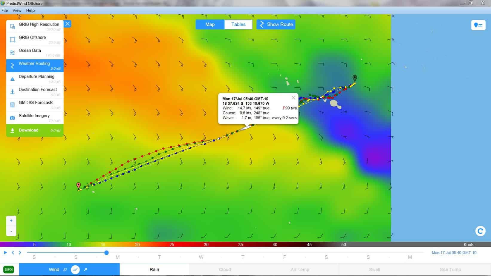
PredictWind Offshore provides access to four different forecast models; the proprietary PWG and PWE models, and the more publicly available GFS and ECMWF. The PredictWind models provide a finer resolution than any other models, which can be really beneficial for complicated weather areas. Most of the other weather services use the GFS model, so it’s really nice to have something to compare it to when weather routing. The more data the better.
Easy to use, single screen interface
It is very easy to download new GRIBS and view them. The flow patterns are dynamic and color coded which makes understanding what you’re looking at so much more intuitive. I really like that feature as it felt like looking at Windy.com or a similar high-bandwidth weather product. As nice as a single screen interface is, I would have loved to have the option of a split screen to view different forecast models side by side or even a previously downloaded GRIB to compare to the current GRIB file.
Weather routing
Weather routing is available for Standard and Professional subscriptions. Using GRIB data and a preset polar (a file that tells the program how quickly our boat sails in different conditions and available from the PredictWind website), we can compare routes through each model (see pic above). By clicking on a point in the model it will tell you what conditions to expect at a particular time. There is the option for choosing the fastest passage possible, or the most comfortable. We choose the fastest because we have 8000nm to sail in 4 months time. It is a great feature and makes route planning amazingly easy. I still like looking at the overall GRIB to see what is happening around us, but in every case the weather routing has been bang on what I would have routed myself.
Highly compressed data files
When you’re bandwidth limited, a small file is worth its virtually weight in bitcoin. The file sizes we were requesting were usually in the range of 3k to 25k, which the Iridium GO! downloaded in a trice. When storm clouds were looming it was nice to get the data in seconds. The satellite imagery wasn’t of a high enough resolution to zoom into so what you see is what you get; but that’s just one of the downsides of low-bandwidth, not really PredictWind’s fault.
Excellent and responsive customer service:
We had a little difficulty getting the app to function on the Ipad. I sent an email to customer service and it was sorted out in less than 24 hours.
Pricing:
PredictWind is not the cheapest weather service out there, but it’s not the most expensive and it ranks up there with the best (See Yachting World’s article on weather routing options). A basic package runs about $10/month, while standard, which was totally sufficient for our requirements costs $21-33/month. The Professional package, which opens up features for ocean currents, fine resolution wave GRIBs, sea temp GRIBs, and 1km resolution wind GRIBs costs $42-83/month. Note: to connect to PredictWind directly with the Iridium GO! you need a minimum of the standard package.
Improvements:
As previously mentioned, it would be nice to have the option of a split-screen mode for the app when not connected to the internet, or multiple windows to make cross-referencing different models easier. By far the biggest improvement would be to include the latitude and longitude either on screen or constantly updating as the cursor scrolls across the map. *Update: PredictWind has indicated that this is on the docket for the next version and the developers are already working on it. Improvements aside, this is a great product that we will continue to happily use.

Robin was born and raised in the Canadian North. His first memory of travel on water was by dogsled across a frozen lake. After studying environmental science and engineering he moved to Vancouver aboard a 35’ sailboat with his partner, Fiona, with the idea to fix up the boat and sail around the world. He has written for several sailing publications including SAIL, Cruising World, and was previously a contributing editor at Good Old Boat.